Contact Us
Site developed by Eddy Barratt, Sam Van Kooten, Than Putzig, and Matthew Perry
Funding provided by NASA MFRP Grant NNX11AM33G
PGG Grant NNX14AN09G
PGG Grant NNX17AB25G
JPL Subcontract 1639821
Hosted by the Planetary Science Institute in Tuscon, Arizona
Previously hosted by the Southwest Research Institute's Planetary Science Directorate in Boulder, Colorado
Welcome to MARSTHERM, the home of
thermophysical analysis tools developed by Mars researchers at the
Planetary Science Institute in Tucson, Arizona and other institutions.
If you are a first-time user,
please register for a free
account.
Otherwise, please
login to access our thermal modeling tools.
Citation Information
Please acknowledge MARSTHERM in any publication featuring products from this system using the reference provided below.
Putzig, N.E., Barratt, E.M., Mellon, M.T., Michaels, T.I., 2013
MARSTHERM: A Web-based System Providing Thermophysical Analysis Tools for Mars Research
Abstract P43C-2023. Poster presented at the AGU Fall Meeting in San Francisco, Decemeber 12.
MARSTHERM Features
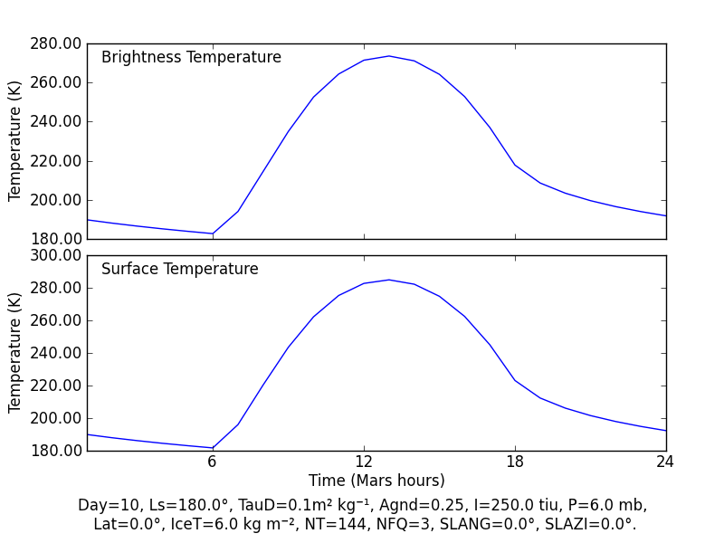
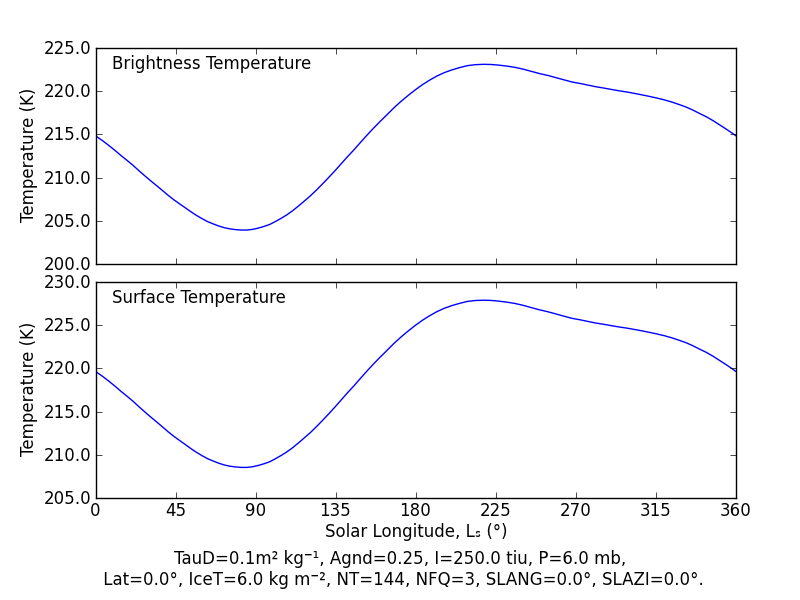
The Thermal Model
The heart of the MARSTHERM thermophysical analyis tools is the thermal model
(Putzig and Mellon,
2007). Users may specify the location and properties (thermal inertia,
albedo, slope angle and azimuth, amongst others) of a surface site on Mars,
and the model will calculate the diurnal or seasonal variations in brightness
and surface temperatures.
Thermal Model Documentation
Model diurnal temperatures at
northern fall equinox on the Martian equator.
 |
|
Model seasonal temperatures at
08:00 on the Martian equator.
 |
|
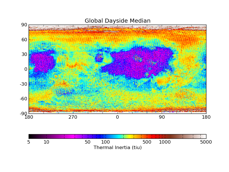
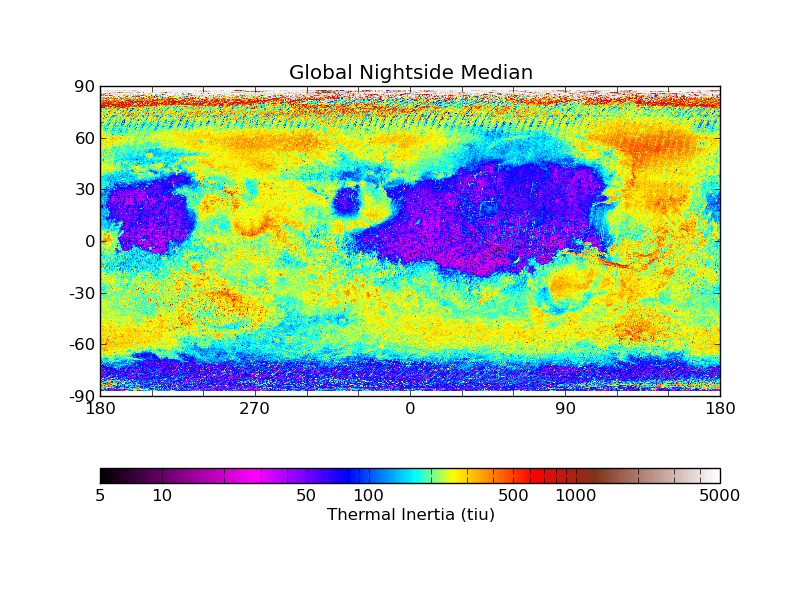
TES and MOLA Global Maps
Putzig and Mellon
(2007) generated a lookup table from the thermal model and used it to
derive apparent thermal inertia from single-point temperature measurements by
the Thermal Emission Spectrometer (TES) onboard the Mars Global Surveyor (MGS).
Nightside and dayside global maps at 20 pixels per degree were produced and may
be viewed or downloaded. Annual-median maps and two varieties of seasonal maps
are also available, with the latter binned in solar longitude at Δ10°
Ls and Δ40° Ls.
Because albedo can change dramatically after dust storms, annual maps of albedo
were produced for the four Mars years of the MGS mission and used in the
derivation of thermal inertia. Additionally, a global elevation map at the same
3-km resolution as TES was created from Mars Orbiter Laser Altimeter (MOLA)
data to calculate surface pressure. These maps are also available to view or
download.
User Projects
Users may designate areas of interest as projects for examining TES results and
for processing THEMIS images for thermal inertia (see next section). Creating a
new project causes MARSTHERM to extract regional maps from the global ones of
MOLA elevation, TES albedo, and TES thermal inertia, and it will also produce a
history of TES atmospheric dust opacity that is needed for THEMIS processing.
Seasonal curves of TES and model apparent thermal inertia are produced, the
latter for a series of simple two-component surfaces. All of the trimmed maps
and regional data sets can be viewed or downloaded.
Projects Documentation
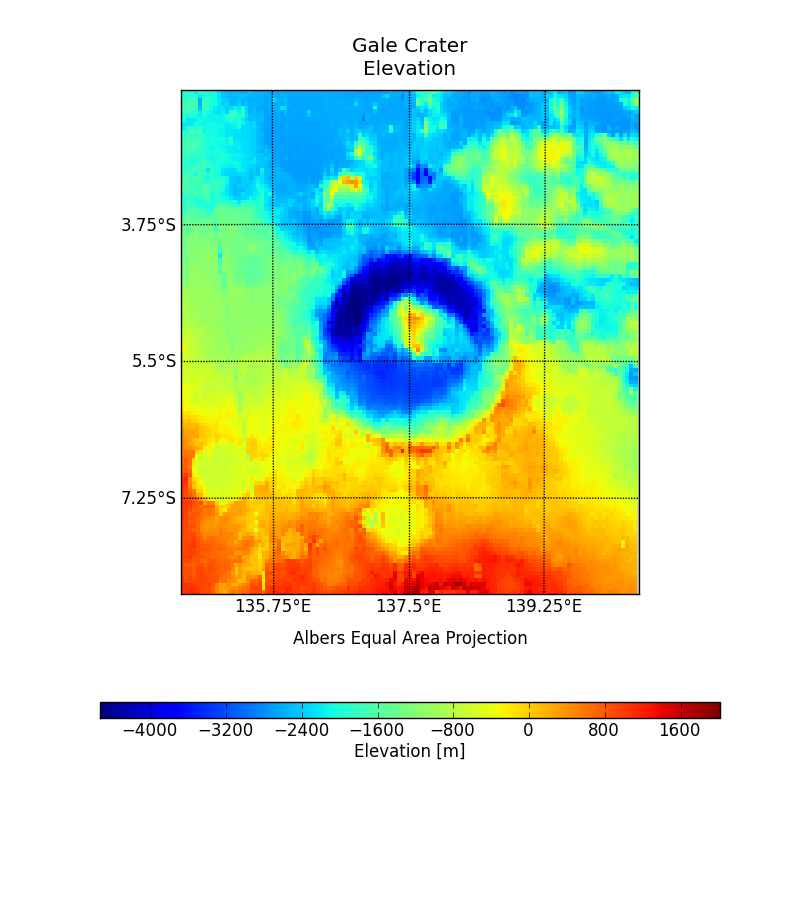
Map of MOLA elevation created for a project centered on Gale Crater.
 |
|
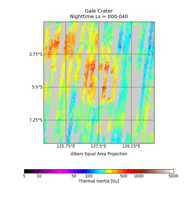
Map of TES thermal inertia created for a project centered on Gale Crater.
 |
|
THEMIS Thermal Inertia
The same derivation technique used for TES can be applied to 100-m-per-pixel
images taken by the Thermal Emission Imaging System (THEMIS) onboard the Mars
Odyssey orbiter
(Putzig et al. 2014). To process THEMIS images for thermal inertia, users
are required to define a project area (see previous section). Limiting the
image processing to areas of interest is necessary due to the level of
available computing resources. MARSTHERM provides links to help users find
images that sample regions of interest, and it will process a user-provided
list of images to derive apparent thermal inertia, producing HDF5 data files
and georeferenced TIFF images.
THEMIS Processing Documentation
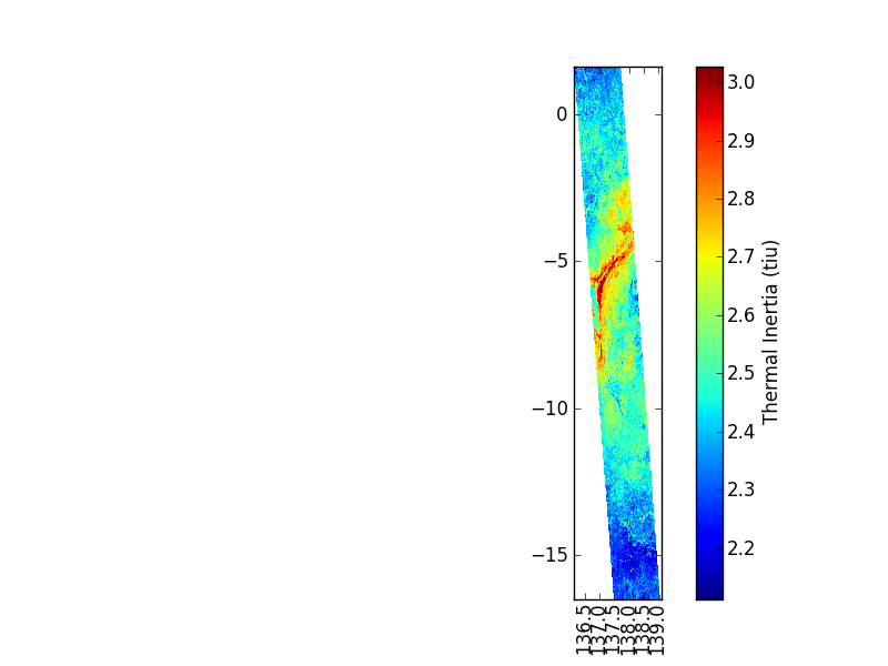
Thermal inertia from a THEMIS image of Gale crater.
 |
|
A subset of the THEMIS image at left,
overlain on a Mars Context Camera image using Quantum GIS, demonstrating the
high resolution of THEMIS images. Elongated feature at center in lower thermal
inertia trending to southeast is Peace Vallis.
 |
|
")